
Note: This post is the second installment of a multi-part series about the two weeks I spent cruising the Caribbean with my little brother. In this chapter, I regale you with tales from land days 4 through 7 as we anchored in St. Barts, St. Kitts, and two of the BVI’s.
In my previous post, I covered what life aboard the Star Breeze was like, and touched upon the first few stops we made along our route. We left off as we departed Guadalupe making our way to Saint-Barthélem. So let’s dive right into it.
St. Barts 101 🇫🇷
Saint Barthélemy was for many years a French commune forming part of Guadeloupe. In 2003 the island voted in favor of secession from Guadeloupe to create a separate overseas collectivity of France.
This island is more commonly known as St. Barts. It is a small, volcanic island located in the northwest Caribbean Sea. It’s among four territories referred to as the Leeward Islands, a grouping which includes the French West Indies, Guadeloupe, and Martinique.
St. Barts is located about 21 miles southeast of the Dutch-country Saint Martin (our final destination on leg 1 of the cruise). Roughly 112 miles east of Puerto Rico, and about 22 mi north-east of the Dutch islands of Saba, Sint Eustatius, and the independent country of Saint Kitts and Nevis (our next stop after St. Barts).
Keep in mind that St. Barts is a relatively small island, with a land area of 8.5 sq mi and a population of about 10 thousand, yet it is still a popular tourist destination. The Island’s economy relies upon the nearly 200,000 travelers who visit every year. This island fully encircled by shallow reefs, and it is generally considered one of the most beautiful islands in the Caribbean.

Tourists are drawn in by its tropical climate, white, sandy beaches, and sophisticated lifestyles. St. Barts is known as the place for the rich in the Caribbean. In fact, it is quite the alluring destination for my clients. For starters, it’s a territory of the EU, so European citizens can move to St. Barts with ease and live tax-free.
The one caveat, you first have to be a resident of France and pay the relatively high taxes of the country for three years. Then, you have to live in St. Barts for half a year before being able to get their tax-free residency.
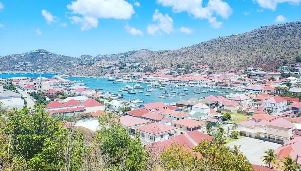
St. Barts’ is a French-speaking island, and its customs and traditions are greatly influenced by French culture. The capital city of Gustavia offers all the comforts of an upscale urban life, including boutiques, restaurants, and dozens of hotels and villas. By contrast, in more rural areas of the island, you’ll find stunning natural landscapes to explore.
Today island’s capital has only around 3k residents. Gustavia remains primarily a port with many shops along the waterfront. The town is shaped like a horseshoe around a small, sheltered harbor, which was once protected by stone forts, the skeletons of which still remain today.
Land Day 4: Old forts and beautiful views in St. Barts

We were dropped off at the port in Gustavia, and we decided to take a stroll down the streets in the area, seeing the glittering jewelry stores and designer boutiques. There are also some impressive old wooden and stone buildings with restored facades, which still remain from the Swedish era.
Among the notable structures in the town are the three forts built by the Swedes for defense purposes. During the Swedish period of saint Bart 91784-1877), four forts were built to defend Gustavia against external attack: Fort Karl, Fort Gustaf, Fort Oscar, and the English Fort.
From the harbor, we visited the ruins of the Fort Gustave, located at the top of a hill near the port. This fort was built in 1787 by the Swedish as one of three fortresses to protect the harbor. The site today has the remains of a vaguely bottle-shaped lighthouse along with vestiges of a stone guardhouse, cisterns, and four cannons, including two on loan from a Swedish maritime museum.
On the outskirts of Gustavia lies Fort Gustav, built in 1787 by the Swedish, this fort sits on top of a beautiful, steep hillside. It provides a perfect view overlooking the port that was once the refuge of pirates, and today hosts a variety of spirited regattas. Come and visit Fort Gustav and see the spectacular lighthouse and old-time cannons and learn about the historical events that happened there.
Not much to see of the fort itself, the main reason to make the trek up to Fort Gustave is for the panoramic view of Gustavia and the harbor. From the top, we had beautiful sights off the steep cliffs and all the land below.
After, we visited Shell Beach, which is a short walk from the center of Gustavia. Described in its name, Shell Beach is loaded with shell fragments throughout the sand. This may hurt your feet but is ideal for collecting vacation memorabilia and enjoying a magnificent sight. After, we went to a beach club nearby and enjoyed our lunch at a stunning beachfront.
Fort Oscar, at the tip of the Gustavia Peninsula, houses the French military (St. Bart’s is officially part of France) and a prison and is still active. We could see it from the ship in the harbor, and later from the lighthouse.
Then we walked some more through St. Barts and ended up at another fort, Fort Oscar. Which overlooks the sea is located on the far side of La Pointe. However, the ruins have been replaced by a modern military building which now houses the local gendarmerie, so you can’t really go in and see anything, but you do still get beautiful views of nearby islands such as Sint Marteen, St Kitts, and Nevis as well as other distant islands.
From there, we had pretty good views of a stunning sailing ship, lying just offshore. It is one of the most expensive sailing yachts in the world with 3 or 4 masts. It can always be found docking between Sint Marteen and St. Barts for locals and visitors to marvel at. It is owned by the Russian billionaire Andrey Melnichenko, and it is an eight-level Sailing Yacht A. Measuring 468 feet long, with masts stretching 300 feet into the air, it is currently the largest sailing yacht in the world.

After we visited Fort Oscar, we went back to the beach and stopped at a bar for a drink. After, we continued to wonder a bit around town, and I got myself some delicious ice cream before making our way back to our ship for our standard evening programming.
St. Kitts and Nevis 101 🇰🇳

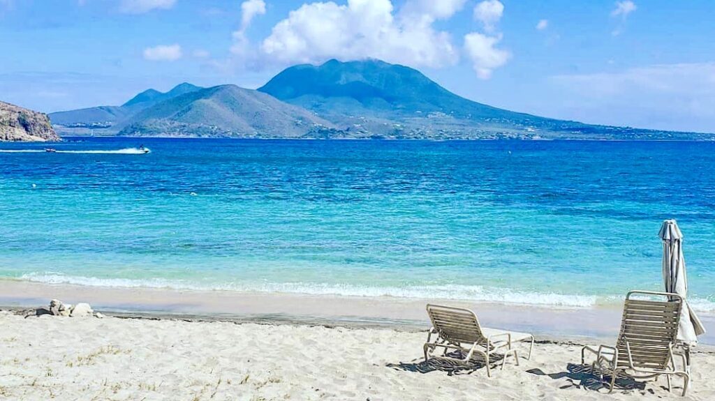
The next day we arrived in St. Kitts and Nevis, a pair of tropical islands in the West Indies. Located in the Leeward Islands chain of the Lesser Antilles, it is the smallest sovereign state in the Western Hemisphere, both area and population.
Like many other places in the Caribbean, Saint Kitts and Nevis were changed hands many times between English and French, which has left it a heritage of cities with names from both countries. Today, the country is a Commonwealth realm, with Elizabeth II as queen and head of state.

The capital city is Basseterre on the larger island of Saint Kitts and where we anchored. So for this stop, we only had time to explore St Kitts and not Nevis.
To see the island, we booked a rental car, which we wanted to drive all around the island.
I am actually driving with my brother through Sweeden at the moment, and he actually remembers this stop, he actually quite liked this island. It has a mountain range in the middle of, and he really liked hiking through this lush, green forest – which was quite beautiful.
Land Day 5: Old forts and stunning views, this time in St. Kitts.
Our first destination was Brimstone Hill Fortress National Park, which is a UNESCO World Heritage Site. It is a well-preserved fortress at the top of a hill. It was designed by British military engineers and was built and maintained by African slaves. It is one of the best-preserved historical fortifications in the Americas.

The complex of fortifications was constructed on Brimstone Hill, a very steeply sloping hill situated close to the sea on the Western, Caribbean coast of St. Kitts. To get there, we had to drive up a really steep and winding road, which basically went up in a zig-zag.

From the top, you get some charming views of the interior of the island and the mountain range in the middle. From there, you can also see the sea on the other side and even spot other islands in the Caribbean, like the dutch islands of Sint Eustatius and Saba.

After the fortress, we went to see some sugar cane plantations and drove through and old town to some secluded beaches. After seeing some of the nature around the island, we went to Basseterre, the capital, to drive around that area a little more.

Then, we went around to the southern part, which is a bit more developed, and it’s where all the resorts are. In this area, we also went up another hill with great views of all the luxury resorts in the area.
After visiting the south, we went back to the capital, returned our rental car, and made our way back onto the Star Breeze. That night, we cruised over to the British Virgin Islands.

Did you know that you can basically buy a St. Kitts citizenship by:
a) Donating 100k to their hurricane fund, or
b) investing 250k into the island.
Either option gets you the citizenship, which is a pretty cool one if I may add. I believe it gives you have access to around 150 countries visa-free, including the EU.
Anyways, as you probably already know, most of the other islands in this region, i.e., St. Lucia, Dominica, Barbuda, Grenada, etc. – also have programs like this.
British Virgin Islands 101 🇻🇬
The British Virgin Islands are a self-governing British overseas territory, situated in the Caribbean just to the east of the US Virgin Islands. The BVIs, as they are called, are a popular travel destination for sailors, fishermen, sun worshippers, and other independent travelers, albeit not for the cost-conscious. If you’re boating among the dozens of tiny, mostly uninhabited, islands, this is a must-do stop on any tour of the Caribbean islands.
The British Virgin Islands comprise 60+ islands and keys, with more than 43 of them being uninhabited islands. The islands fall into two types: the majority are steep volcanic islands (including the main islands, Tortola and Virgin Gorda), and a small number of relatively flat coral islands (such as Anegada and Sandy Spit).
Land Day 6: BVI’s Jost Van Dyke

Our first stop on the BVI’s was Jost Van Dyke, sometimes colloquially referred to as JVD or Jost, which is the smallest of the four main islands of the British Virgin Islands, measuring roughly 3 square miles. It rests in the northern portion of the archipelago of the Virgin Islands, located in the Atlantic Ocean and the Caribbean Sea. Jost Van Dyke lies about five mi to the northwest of Tortola and five mi to the north of Saint John.

Like many of the neighboring islands, it is volcanic in origin and mountainous. The highest point on the island is Majohnny Hill at 1,053 ft. Our first stop in JVD was White Bay, a pretty famous spot among sailors. Its a beautiful horseshoe bay with white sand and clear waters.

There, we visited the Soggy Dollar Bar, a famous beach bar on the island. It is reputedly the birthplace of the popular drink known as the Painkiller. They also claim to have other extraordinary cocktails, so obviously, my brother and I had to check it out. We ended up not having only one, but rather a few drinks there.

I started with my all-time favorite, a Dark and Stormy – only real ones, made with dark rum – this time it was made with some delectable Gosling Black Seal rum from the Bermuda Islands, it was as good as it sounds. We then indulged in the famed painkiller cocktails, and at this point, we were getting quite drunk, they make these drinks very strong.

So yeah, if you’re ever in the area, make sure to pay the Soggy Dollar a visit, it’s good times guaranteed. Fun Fact: the bar got its name because when it was first opened, there was no road or port. To reach the beach, It was (and still is) customary for sailors to anchor about 5 meters from the beach, swim to shore, and pay with wet money.
If the Soggy Dollar is not your cup of tea, White Bay is lined with beach bars to choose from. Keep in mind this place is not a very popular stop for yachts and boaters from Tortola, St. Thomas, and St. John. Group tours from the USVI and even small cruise ships like ours are also frequent visitors, so there is always a mixed crowd and good vibes.
After drinks, we just wandered around the beach and went for a nice, refreshing swim. We didn’t really do much else, just relaxed a bit and enjoyed our time with some Painkillers. Before we knew it, it was time to make our way to the beach, where we would catch our tender boats back to the ship.
The Star Breeze was waiting at different bay, and I remember we had to go up this steep road and then back down towards the bay to get to it. Going to and from White bay were the toughest parts of the day. Quite a lot of work but it was definitely worth it, we had a lot of fun at this beach.

Land Day 7: BVI’s Virgin Gorda

The next day, we were still in the BVIs, cruising past Tortola, the largest of the British Virgin Islands, and the US Virgin Islands – one of the territories still missing for me in the Caribbean, but at least I got a glimpse of it so that counts for something. :() – as we were making our way to Virgin Gorda.

We docked in Virgin Gorda, which is the third-largest (after Tortola and Anegada) and second-most populous of the BVIs. Windstar had prepared a nice beach party and BBQ buffet for the guests.
Most people decided to get very drunk at the beach, but we chose to see instead of one of the principal commercial and residential area of Virgin Gorda, called the Spanish Town on the southwestern part of the island.
Spanish Town is the second largest town (after Road Town) on the British Virgin Islands. This area is small, with few bars and a relaxed atmosphere.

From there, we made our way to the national park “The Baths”, which is located south of Spanish Town. The Baths is an unusual geologic formation that has made Virgin Gorda one of the BVI’s major tourist destinations.
At the Baths, despite evidence of the island’s most extensive volcanic origins, huge granite boulders lie in piles at the beach, forming scenic grottoes that are open to the sea.

It is odd to find granite there because it is an intrusive igneous rock, thus not volcanic. However, it did form from magma with pressure from great depths. This granite only became exposed at surface after the ages of erosion removes the overburden.
Further erosion in this spot broke the granite into large boulders and rounded their exteriors and edges. It was fascinating to see all of this; there were also some naturally formed ladders and steps that come from the water. Pretty interesting to go there, there were some natural ladders as well, coming from the sea.

We began to walk on these steps, and in some moments, we had to wait for the water to reside to be able to quickly climb the stairs, making our way through this maze of stones. It was cool.
On the other side, once you get out of the maze, there was also a gorgeous beach; there was even one stunning beach, but it had really big and powerful waves braking through our path, so we didn’t really feel like walking or swimming there. It was still really great to witness.
After exploring the main sites of Virgin Gorda, we went back to the beach party, just in time to go back on the boat and prepare for the evening itinerary. Delicious dinner with my brother over a nice bottle of wine capped off with drinks at the bar over a match of chess. Pretty standard, but I wouldn’t have it any other way. 😉
This is it for this post, but click here if you want to continue reading about our adventures in the remaining destinations, and as we begin the second leg of the cruise through Anguilla, Sint Marteen, and Montserrat.


